
Thursday, March 31, 2011
Phra That Doi Pu Khao
Wednesday, March 30, 2011
The King Mengrai the Great Memorial
 It is located in the town on the intersection leading to Mae Chan. Originally, King Mengrai was the ruler of Nakhon Hiran Ngoen Yang (an ancient town on the bank of the Mae Khong around Chiang Saen) before Chiang Rai was established as the administrative centre in 1262. He consolidated his power by merging the different city in the North and founded the Lanna Thai Kingdom in 1296 with Chiang Mai as the capital.
Tuesday, March 29, 2011
Golden Triangle Thailand

Travel approximately 9 kilometers north of old town Chiang Saen, along the road parallel to the Mekong River to the area where the borders of Thailand, Myammar and Laos converge. This area where the Mekong River meets the Ruak River is locally referred to as "Sop Ruak". Within this area are remains of many ancient places and structures attesting to the fact that the area had been settled by people in the past. It is also the area where various legends concerning the Lanna ancestors originate.
Boats can be hired in order to view the upstream scenery of the Golden Triangle and to travel downstream to Chiang Khong. The trip to the Golden Triangle and Chiang Khong would take approximately 40 minutes and 1 hour respectively, depending on river currents and water levels.

Monday, March 28, 2011
Wat Phra That Doi Chom Thong Chiang Rai

Sunday, March 27, 2011
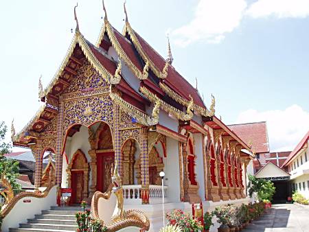
Wat Phra Sing
 Wat Phra Sing is located near the townhall used to house a major Buddha statue, the Phra Buddha Sihing which is now enshrined in Chiang Mai. A special feature is the Lanna-style Ubosot and the wooden door panels carved by Chiang Rai contemporary craftsmen.
Saturday, March 26, 2011
Floating Market Damnoen Saduak in Bangkok

Nowadays Damnoensaduak is one of a provincial district of Rajburi Province. Most people live densely along both sides of the canal from one end of the canal to another.The majority of this people are agriculturists. They grow several different kinds of fruit and vegetable for examples oranges, grapes, papayas, cabbages, bean, onion and etc. The land in this area is naturally fertile. Apart from providing transportation, Damnoensaduak Canal also provides farmers with adequate water for agricultural purposes for the whole year around. More than 200 small canals were dug by local peasants to connect with it to get water to splatter their land. Moreover; these small canals also become protitiouus ways of taking their agricultural products to the markets in neighbouring provinces and Bangkok.
Day in and day out from about 8 a.m. to about 11 a.m. the Floating Market is routinely crowded with hundrreds of vendors and purchasers floating in their small rowing boats selling and buying or exchanging their goods. What they purchase are particularly food, fruit and vegetable which mostly brought from their own orchards. They usually travel on their small rowing boats. however; today the long-tailed boats pushing by engine become very popular. People tend to use them instead. Anyhow because of the shortage of fuel today long-tailed boats are quite unavailable compared to a few years ago.
Damnoen Saduak in Ratchaburi about 109 kilometres south of Bangkok
Friday, March 25, 2011
Sanctuary of Truth, a Wooden Wonder

Thursday, March 24, 2011
The White Temple - Wat Rong Khun
 Wat Rong Khun is different from any other temple in Thailand, as its ubosot (Pali: uposatha; consecrated assembly hall) is designed in white color with some use of white glass. The white color stands for Lord Buddha’s purity; the white glass stands for Lord Buddha’s wisdom that "shines brightly all over the Earth and the Universe."
All the paintings inside the ubosot (assembly hall) have golden tones. The four walls, ceiling and floor contain paintings showing an escape from the defilements of temptation to reach a supramundane state. On the roof, there are four kinds of animals representing earth, water, wind and fire. The elephant stands for the earth; the naga stands for water; the swan's wings represent wind; and the lion’s mane represents fire.
Visitors will find it rather bizarre to find modern images throughout this temple. Images of the Predator from the Hollywood film, Spiderman, Batman, Keanu Reeves character in the Matrix, rocket ships, etc. The sea of hands rising up towards the bridge to the temple, some holding skulls are very striking.
In 1997, Chalermchai Kositpipat volunteered his service to carry out the construction of the ubosot at his own expense as an offering to Lord Buddha, but he later altered the plan as he saw fit in such a way that Wat Rong Khun developed into a prominent site attracting both Thai and foreign visitors.
Nowadays, Wat Rong Khun is still being constructed. When completed, the construction project of Wat Rong Khun will consist of nine buildings: the ubosot, the hall containing Lord Buddha’s relics, the hall containing Buddha images, the preaching hall, the contemplation hall, the monk’s cell, the door façade of the Buddhavasa, the art gallery, and the toilets.
Wednesday, March 23, 2011
The History Chiang Rai

In 1432 during the reign of King Sam Fang Kaen of Mangrai dynasty (1402–1441) the Phra Kaeo, or Emerald Buddha, the most revered Buddha statue, was discovered in Chiang Rai when an earthquake split the Chedi at Wat Phra Kaeo of Chiang Rai City. The beautiful jade figure was then seen concealed within. Another telling of the story has the 'Emerald Buddha' hastily covered in mud just before marauders entered to pillage. It wasn't until many years later, that the clunky-looking mud Buddha was found to actually house the magnificent jade statue, perhaps by way of the earthquake mentioned above - which caused a piece of the clay to break off - revealing the jade beneath.
In 1992, the City Pillar was moved from Wat Klang Wiang to Wat Phra That Doi Chom Thong, where it is known as Sadue Mueang (Thai: สะดือเมือง), the Navel or Omphalos of the City
Tuesday, March 22, 2011
Chiang Rai in Thailand

Chiang Rai City is 200 kilometres northeast of Chiang Mai City, 62 kilometres south of Mae Sai and the Burmese border; 60 kilometres southwest of the town of Chiang Saen on the Mae Kong across from Laos; and 90 kilometres north of Payao town.
The Mae Kok River runs along Chiang Rai's north side, flowing from west out of Burma at Taton town - to east and thereby merging with the Mekong River.
There are four bridges spanning the Mae Kok river within the town's boundaries, each running south/north. Most of the terrain surrounding Chiang Rai town is either flat or has moderate hills. The exception is outward in the west and northwest directions, where limestone hills are evident, some of which have straight-up exposed cliffs. Not surprisingly, that's also the direction where most of the region's Hill Tribe people have their villages, further afield.Monday, March 21, 2011
Doi Suthep Temple Music:Chanting By Imee Ooi

Doi Suthep is a constant part of life in Chiang Mai. A Thai saying goes, "If you haven't tasted Khao Soi or seen the view from Doi Suthep, you haven't been to Chiang Mai." This regal mountain overlooks the city from the northwest, providing commanding views from its summit. Aside from its dominating presence on the horizon, Doi Suthep is the home of some of the most deeply loved symbols in the Kingdom.In 1981 Doi Suthep, Doi Pui and Doi Buakha, along with the 161 square kilometres (62 square miles) of forest in which they are located, became Thailand's 24th national park. A year later a 100 square kilometre (38 square mile) annex was added, bringing the park's total area up to 261 square kilometres (100 square miles). Dense forests hang from the mountain's shoulders like a cloak; deciduous at lower elevations and evergreen near the peaks of the mountains.
Sunday, March 20, 2011
Doi Inthanon in Chiang Mai

Formerly known as Doi Angka, the mountain now bears (since 1899) a shortened version of the name of Chiang Mai's last sovereign, King Inthawichayanon. During his reign, he had, with great foresight, expressed his concern for the forests of the northern hill country as the watershed for all of central Thailand. The modern study of rain forest hydrology has borne out his early convictions and given substance to Thai folklore which describes this hill region as the home of the Phiphannam, the 'spirit who shares water'. Before the King died near the turn of this century, he commanded that his remains be placed at the top of this mountain: his ashes at the summit stupa are visited by thousands of people each year.
The park covers an area of 48,240 ha. Its lowlands below 800 meters in elevation are warm and very dry during the rain-free season, but the summit of Doi Inthanon, at 2565 meters, has a climate more like Canada than Thailand. The temperature has been known to drop as low as -8 degrees C. and frosts are not unusual during the cool, dry season. January is the coldest month: an average nighttime temperature is 5.5 degrees C. At any season, Doi Inthanon is a comfortable reprieve from the heat of the lowlands. At altitudes above 1000 meters, rainfall exceeds 2500 mm, considerably more than at nearby Chiang Mai. Even in the dry season, November to April, there is rare but occasional rain or the summit may be shrouded in cloud for a part of the day; persistent mist is an important factor in the maintenance of moist forest there.
 The various sub montane forest formations at higher elevations are a unique asset of the park. They have dominant species belonging to temperate climate families rather than tropical. The summit area supports the only red rhododendron in Thailand (R. delavayi); it blooms from December through February. There are also two white-blossomed species abundant on Doi Inthanon which are restricted to only a few other sites.
 Where mists are persistent, the slopes carry a moist hill evergreen or 'cloud forest' with many epiphytes, plants which live on tree trunks and branches but do not receive their moisture and nutrients from the host tree as do true parasitic plants. Instead, they are nurtured by the accumulation of dust particles and humus around their 'root' area and the moisture retained there, augmented by frequent bathing in cloud and mist. Epiphytic orchids are also abundant, along with lichens, lianas and fern.
 At mid-elevations, 800 - 1500 meters, two species of pine are present, Pinus merkusii mixed with dipterocarp in the lower range, and P. kesiya with oak and laurel on drier slopes in the upper range. The pines are thought to be a relic from a prehistoric cooler climatic period when flora from the Sino-Himalayan region migrated southward. At the mid-elevations of the park, much of the forest has been removed by the activities of swidden cultivators and the slopes have converted to fire climax grasslands.
 Saturday, March 19, 2011
Chiang Mai National Museum

The museum begins with the natural and cultural background of the region, including the ecology and geography of the north, as well as information on prehistoric settlements. From there the museum tells the history of the Lanna Kingdom from the founding of Chiang Mai in 1296 through its sacking by the Burmese in 1558 until it was again liberated with the aid of the King of Siam in 1769. The next section deals with the short period of time during between the city's liberation from the Burmese to its re-establishment in 1782, during which period the city was under control of the King of Siam. Ascending to the second floor, visitors will find an exhibit hall devoted to the trade and economy of the Lanna Kingdom until its integration with Thailand in 1939. The next section displays photographs and artefacts showing the modern life of Chiang Mai - its agriculture and industry, and its relation to the national and global community. The final exhibit focuses on the unique art style of the Lanna Kingdom, displaying numerous distinctive artefacts from the 13th century all the way up to contemporary pieces
Friday, March 18, 2011
Wat U-Mong in Chiang Mai

Off the beaten track and more than a little odd is Wat U-Mong, which is located about 1 km south of Suthep Road, west of the canal. The halls of this temple are actually tunnels which crisscross an artificial mound.
The tales say that this temple was built for a highly revered monk who was so in touch with the Buddha that he was a little out of touch with everything else and had a habit of wandering off. The temple grounds are heavily forested, owing partially to the temple's long period of abandonment. Between the maze of tunnels and the overgrown jungle you may find yourself wishing you had a fedora and a bullwhip. Thursday, March 17, 2011
Wat Chang Kong Chiang Mai
 Wat Chang Kong is located on Loi Kroh Road. It was constructed by Chang Kong villagers who immigrated from Chiang Sean at the beginning of the Rama Period it now stands as an abandoned chedi which is completely surrounded by shops and dwellings on three sides.
Wednesday, March 16, 2011
WAT PHAN TAO CHIANG MAI

Tuesday, March 15, 2011
Chiang Mai Temples and Wats
In ancient times kings built temples to demonstrate not only their devotion, but also their wealth and power. Temples served not only as centres of faith, but also as schools and hospitals. Today, temples are still a central part of Thai life and the holy structures of Chiang Mai are living, breathing places that serve as invaluable bridges to the past, keeping the people linked to the timeless traditions of their ancestors.
Sunday, March 13, 2011
Kawila Monument and Park in Chiang Mai

Wat Chedi Luang in Chiang Mai

Saturday, March 12, 2011
Wiang Kum Kam Chiang Mai

Wiang Kum Kam as the capital city is slightly different from those of other ancient capitals. Rather than being left in ruin, the city was completely submerged under the Ping River, which suddenly changed its course and swept the whole city under. Had it not been accidentally rediscovered (in 1984), the story of Wiang Kum Kum would just be a legend.After a number of archaeological expeditions were carried out, experts unearthed extensive city foundations and more than 40 ancient structures within an area of 850 metres long and 600 metres wide. The Fine Arts Department has done restoration works on some of the structures whereas many are left in their original ruined state and others completely destroyed by the floods, leaving only traces of their previous existence. Wiang Kum Kam is Wat Chedi Liam (or Temple with an Angular-based Chedi). Widely depicted in postcards, the temple features a Burmese-style pavilion (restored in 1908 by a Burmese trader) and a five-tiered chedi set on a square base – the signature style of the early Lanna period. Each corner of the chedi is guarded by an outward-facing lion, an architectural feature that is unique to the Haripunchai style (today’s Lamphun). Other important structures include Wat Chang Kham, containing the spirit house of King Mengrai (founder of the Chiang Rai and Chiang Mai kingdoms) and the Cultural and Local Wisdom Learning Centre which exhibits Lanna objects and traditional Lanna-style houses. It’s a good idea to drop by Wiang Kum Kam Information Centre, where excavated earthenware pottery and artifacts are displayed in the exhibit rooms.
Friday, March 11, 2011
Chiang Mai Thailand
 Chiang Mai is the largest and mostculturally significant city in norther n Thailand. It is located 700km (435 miles) north of Bangkok in some of the highest mountains in the country. The city was founded in 1296AD as the capital of the Lanna kingdom. Its location on thePingRivermadeit an important city on the trade route. Many Buddhis
templesor‘wats’ were built within the moated city walls and they still can be visited today.The most famous buildings are the Wat Phrathat Doi Suthep with its golden chedi and the Wat Chiang Man, which dates back to the 13th century. It holds the Phra Sila, a marble Buddha and a crystal Buddha. Chiang Mai is often used as a starting point for treks through the jungle and visits to the nearby Elephant Nature Park. Night bazaars sell local handicrafts including locally made woven goods and umbrellas.
Thursday, March 10, 2011
Wat Arun Temple of Bangkok

Wat Arun, the Temple of Dawn, is one of Bangkok's best know landmark. It stands on the west bank of the Chao Phraya River in Thon Buri. Wat Arun is best seen from the opposite bank of the river; it glistens in the sunlight during the day and stands dark and noble at dawn or dusk. A visit to the beautiful, peaceful monastery complex surrounding the familiar towers is very worth-while. These towers, the "Phra Prang," although best known, the only part of Wat Arun. It also contains narrow lanes; elegant, old white buildings; shrines, pools of turtlesand two fine giants, " Yuk Wat Jaeng," mortal enemies of the " Yuk Wat Po" across the river.
The monastery has existed for many years since the days when Ayutthaya was capital of Thailand. It was then named Wat Mokok, situated in a place called Tumbol Bangmakok. The word Bangmakok, meaning " Village of Olive", has since been shortened to " Makok".
When King Taksin and his army reached this place to build his new capital Thonburi, after defeating the Burmese who had sacked Ayutthaya, he arrived at dawn. He renamed the monastery he found there Wat Jaeng- Jaeng meaning "clear", "bright" and Construction of the tall prang and four smaller ones was started by King Rama II 1809-1824 and completed by King Rama III (1824-1851). The towers are supported by rows of demos and monkeys. Very steep and narrow steps lead to a balcony high on the central tower. The circumference of the base of the structure is 234 meters, and the central prang is 250 foot high.
Wednesday, March 9, 2011
Buddha in Bangkok

The Buddha lies in its own building and you should dress appropriately to visit it, preferably no bare shoulders or shorts that are entirely too short.
The body of the Buddha is covered in gold, whereas the soles of his feet and the eyes are mother of pearl. The statue is 46 meters long and 15 meters high.
Wat Pho is one of Bangkok's biggest temple wat (sacred precinct), and covers 80,000 square meters. There are over 1000 Buddha statues here and also statues depicting various yogic positions. Indeed, the place was used for the instruction of Thai masseurs and yoga instructors before the temple was built.
Wat Pho still boasts the most famous school for massage artists.
Monday, March 7, 2011
Chachoengsao.
 Just east of Bangkok is Chachoengsao province which occupies an area of 5351 square km. Chachoengsao is approximately 100 kilometers from Bangkok and administratively divided into 9 Amphoes and 2 King Amphoes.
 Chachoengsao province frequently visited by foreign tourists, because there are major rail and rail network from Bangkok. And that is why hardly any tourists know that Chachoengsao province is home to one of the most sacred Buddha images in Thailand.
The Phra Phuttha Sothon Buddha image is housed
in Wat Sothon Wararam Warawihaan and that is 198 centimeters (77 inches) tall. This sacred image
of Buddha is a famous Buddhist monk who had holy powers and actually predict the exact time ofdeath. The church is locatedattheedgeofBangpakong River and was built during the period of Ayutthaya. Then there is the Wat Chin Prachasamoson which is a temple built by Chinese architecture built by the followers of MahayanaBuddhist doctrine. Apart from these attractions, the other attractions in the province of Chachoengsao are various festivals and events are held round the year. In March-April, Paet Riu
Saturday, March 5, 2011
the temple of the Emerald Buddha

The temple is located in old Bangkok, that part of town that is usually referred to as the historical part of Bangkok.
Wat Phra Kaew boasts possession of the very famous Emerald Buddha that has been transported throughout the region for several hundreds of years. This Buddha is very valuable and very important to the Thais. Stolen and moved both within the country and also to other countries in the region, it is now where it belongs according to Thai Buddhists.
Wat Phra Kaew came to be in connection with King Rama I moving the capital from Thonburi that lies on the west side of the Chao Praya river to the eastern side, where the currently most developed part of the city now lies.
The temple is grandiose both given its size and beauty. Given that Thailand and Cambodia to a great extent share the same background and roots, there is also a model of Angkor Wat in the temple area.
Wat Phra Kaew shares the same compound with the Grand Palace, and you must be well dressed to gain admission. In other words, long pants and covered shoulders are obligatory.
You can reach Wat Phra Kaew with the river boat from the Sky Train Station Saphan Thaksin, disembarking at Pier 8.
Friday, March 4, 2011
Siam Center Bangkokangkok

Siam Center lies right next to Siam Paragon and has a bit of a younger and somewhat more stylish attitude and style. You will find a number of small boutiques selling nice clothes designed by youngThaidesigners. The focus here is on clothes, but there are also a number of places to eat in the shopping center.... Siam Center is big but still accessible and can be polished off in half a day, as opposed to other huge shopping centers in Bangkok. Siam Center is found at the Station Siam via the Sky Train.
SIROCCO SKY BAR - RESTAURANT

Located on the 63rd floor of The Dome at lebua, Sirocco is the world's highest al fresco restaurant and one of Bangkok's most coveted dining choices. It never fails to leave one mesmerized with a breathtaking view of Bangkok and the Chao Phraya river, an amazing Skybar and quality Mediterranean fare with ingredients from the world's best markets. Live jazz music featuring vocalists of international repute, adds to its captivating ambiance for a perfect evening.
Thursday, March 3, 2011
grand palace the bangkok

Grand Palace was the dwelling place of the King from the 1700's until the middle of the 1900's. The current king, Bhumibol, now lives in the Chitralada Palace. As such, Grand Palace has been able to be converted into a tourist attraction, the area filled with automatic telling machines and boutiques selling various souvenirs. The palace for the most part is used for various ceremonies. You must dress appropriately in order to be let in to the area, given that the palace is very holy. This implies covered shoes as well as legs and shoulders. Sunglasses are not obligatory but recommendable as to protect your eyes from the blinding reflection from all the precious metal decorating the place. Notable are all the well-dressed Thais outside of the palace that will nearly convince you that the palace is closed. Often this is not the case, so just continue right on past them to the main entrance and find out for your self what the deal is. Wat Pho, Wat Kaew and Grand Palace are all grouped in the same place and the easiest and most pleasant way of getting here is to take the river boat from the Sky Train - Station Saphan Thaksi, disembark at Pier 8 Tha Chang
Tuesday, March 1, 2011
Benjakiti Park Bangkok
 The park is oval in shape and in the middle lies a relatively large dam decorated with fountains. The dam is approximately 2 km in diameter and it is possible to walk, run, bike or rollerblade around it. The park is just a few years old, and is kept fresh and clean. During the day, the park is often completely empty but it gets a bit more lively in the evenings. It is then that elderly Thai men will come to sit and chat, walk around the park or jog. Children are there with their parents learning to bike and groups of youth also run or jog to keep in shape. There are separate paths for bicycle traffic and pedestrians which does keep things running smoothly. In the park there is also a skateboarding ramp, exercise equipment and a large Buddhist meditation center. The park is a small but appreciated refuge for Bangkok's residents and visitors. You can rentbothbicyclesand peddle-boats in the shape of swans, at a little kiosk in the park. The easiest way to get to Benjakiti park is with the Sky Train or the underground to the Asok station, alternatively you may take the underground to Sukhumvit or Queen Sirikrit ConventionCenter
Subscribe to:
Posts (Atom)

